

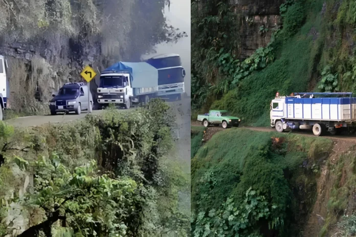
A truck crawls along a dirt track barely wide enough for one vehicle. Rock wall on the left. On the right, nothing but empty air and a drop of hundreds of meters into the green Yungas valleys below. Fog rolls in. Rain turns the surface to mud. One wrong inch and it’s over.
That was daily life for decades on Bolivia’s North Yungas Road, better known as the Death Road or Camino de la Muerte.
Built in the 1930s by the Bolivian government with heavy labor from Paraguayan prisoners of war captured in the Chaco War, the roughly 64-kilometer (40-mile) route connected high-altitude La Paz to the subtropical Yungas region. It dropped more than 3,500 meters (about 11,500 feet) from the Andes toward the Amazon lowlands. Sections narrowed to just three meters (about 10 feet). Guardrails were rare. Landslides, waterfalls crossing the road, and two-way traffic on a single track made every trip a gamble. Drivers even switched to left-side traffic so they could better judge the cliff edge.
In between 1999 and 2003, it was responsible for 200 accidents and 300 deaths per year. The information is taken from historical data presented in a paper released in 2022 in Ecología en Bolivia, mentioned by Wildlife Conservation Society. This is the figure derived from historical data during the period of intense commercial use, but is not a statistically verified annual death rate and certainly not a current figure.
The worst single accident occurred in July 1983, when an overcrowded bus overturned and more than 100 passengers died. In 1995, the Inter-American Development Bank officially declared the road to be the world’s deadliest.
Everything has changed due to the construction of the alternative Cotapata–Santa Bárbara highway that became operational in 2007. Almost all cargo vehicles switched to this safer route. The number of cars traveling through the road decreased by 90 percent. The death toll dropped significantly.
Now the road is less busy. It still attracts adventurers mostly cyclists, who descend the long stretch from the Andes heights to the cloud forest and subtropical vegetation below. The landscape is breathtaking. The dangers related to the narrowness of the road, weather conditions, and lack of safety features are still there, but nowhere near the old times with the constant heavy traffic.
Nature has taken notice. In 2022 the Wildlife Conservation Society reported that camera traps along a stretch of the former route recorded 16 species of medium and large mammals and 94 bird species. The area has become an increasingly important wildlife habitat as noise, dust, and roadkill declined.
The road which used to claim hundreds of lives each year has now become an area for adventure and easier movement of animals. Its past is terrible. Its change is amazing.

